Twin Cities Reel After Overnight Tornadoes Rip Through Metro Area
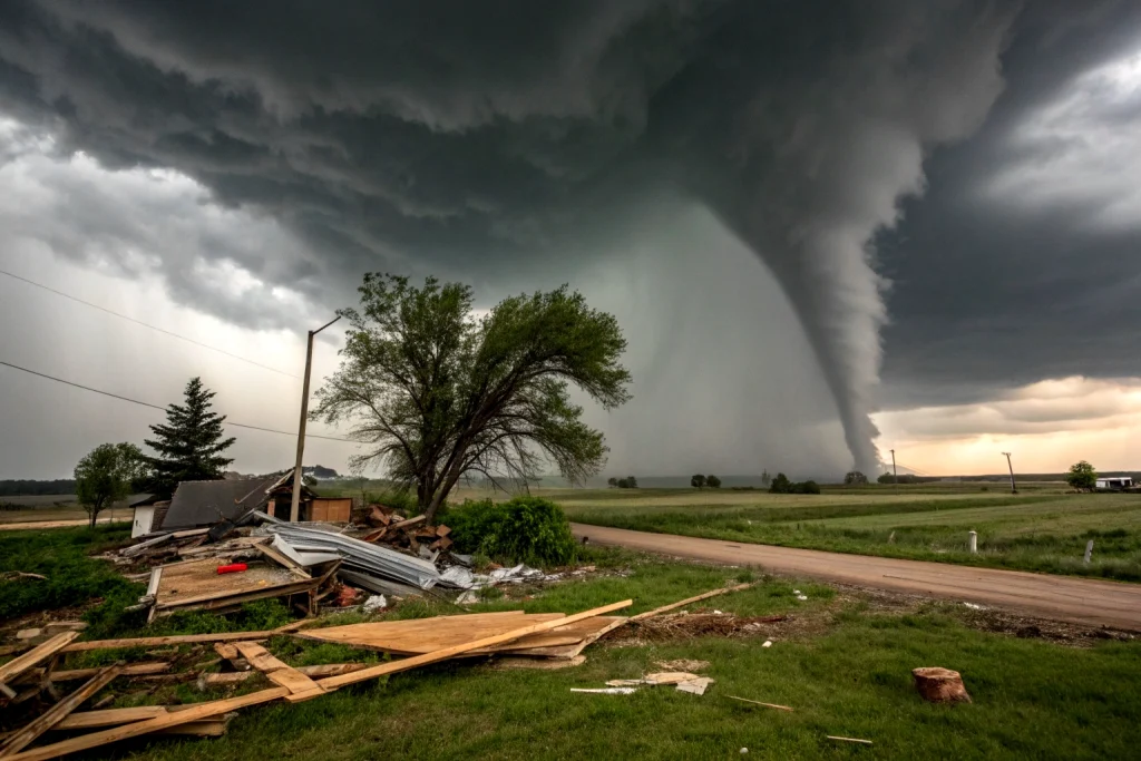
MINNEAPOLIS — Sirens wailed across the Twin Cities metro just after midnight Sunday as confirmed tornadoes touched down in Carver County, capping a chaotic night of severe weather that saw at least seven reported twisters strike Minnesota, including two near Canby, leaving downed trees, damaged property, and rattled residents in their wake. The outbreak marks one of the most significant nocturnal tornado events in recent metro history.
Tornadoes Strike Under Cover of Darkness
The chaos began Saturday evening in western Minnesota when storm spotters documented a tornado near Canby around 7 p.m., followed by another touchdown east of Holloway in Swift County. The Swift County Sheriff’s Office swiftly confirmed the Holloway tornado via social media, urging residents to take cover as the system barreled eastward.
By midnight, the crisis escalated dramatically in the southwest metro. Doppler radar confirmed five separate tornadoes between 12:09 a.m. and 1 a.m. across Carver County—hammering Victoria, Waconia (twice), Cologne, and St. Bonifacius. An eyewitness reported a funnel cloud directly over Waconia just after midnight, moving east at 30-35 mph. Moments later, another was observed over St. Bonifacius, triggering frantic warnings across Hennepin County, including Minneapolis.
“Sirens began going off in Northeast Minneapolis early Sunday,” reported FOX 9, as the National Weather Service (NWS) issued a tornado warning until 1 a.m. for an area stretching from Shakopee to Burnsville, north to Minneapolis and west to Minnetonka. Although the visible tornado threat subsided, the warning stressed storms could produce “another tornado quickly”
Damage and Disruption
Residents awoke to scattered destruction Sunday morning. Highway 7 near Victoria was blocked by downed trees, while other areas reported snapped branches and structural damage. Power outages flickered across neighborhoods as straight-line winds—some severe—accompanied the tornadic cells.
The severe thunderstorm watch, initially covering western counties until 1 a.m., was extended east to include Hennepin, Ramsey, and Carver counties until 5 a.m. as the storm system stalled, dumping heavy rain and raising flood concerns. A flash flood warning was earlier issued for Burr, Minnesota, underscoring the multi-faceted threat.
Today’s Threat: Winds and Hail Replace Tornado Risk
While the immediate tornado threat has passed, the NWS Storm Prediction Center flags a Slight Risk of severe storms Sunday (June 29) for southern Minnesota and western Wisconsin between 2 p.m. and 10 p.m. Damaging winds are the primary concern, with large hail (up to 1 inch in diameter) also likely due to high atmospheric instability.
“Wind is the primary risk, though hail is expected,” noted the SPC’s 12:50 a.m. CDT outlook. The Twin Cities metro faces a 15% risk for severe wind or hail, significantly lower than Saturday night’s tornado probabilities but still warranting vigilance.
Why Such an Explosive Night?
Meteorologists point to a volatile cocktail of ingredients: A warm front lifting north Saturday combined with dew points in the 70s created extreme instability. Strong low-level wind shear allowed storms to rotate, forming supercells capable of spawning tornadoes, echoing conditions that triggered tornadoes in southeast Minnesota just four days prior on June 25.
KARE 11’s Belinda Jensen noted storms initially fired near Alexandria and Brainerd after 6 p.m. before consolidating into a larger system. By 9 p.m., the line stretched “from the North Shore down to Marshall,” hitting the metro between 9 p.m. and midnight.
Recovery and Continued Vigilance
NWS survey teams will assess damage Sunday to confirm tornado counts and intensities. Residents are urged to:
Document Damage: Take photos for insurance and report to local authorities.
Stay Alert: Charge devices and monitor NOAA Weather Radio for afternoon storm updates.
The week ahead offers respite early—sunny skies and highs near 80°F are forecast for Monday and Tuesday—before storm chances return by the Fourth of July
“This was a scary reminder that tornadoes don’t just happen in daylight,” said Minneapolis resident Elena Rodriguez, who sheltered in her basement with her children during the midnight warnings. “We’re just grateful it wasn’t worse.”